Mormon's Map Puzzle Solved?
Reprinted from Meridian Magazine (12 Dec 2006).
©2006 by John P. Pratt. All rights Reserved.
| 1. Map Anchors |
| 1.1 Limited Extent |
| 1.2 Narrow Neck of Land |
| 1.3 Nearly Surrounded by Water |
| 1.4 Two Advanced Cultures |
| 1.5 Narrow Wilderness Strip |
| 1.6 River Sidon |
| 1.7 Names of Large Lands |
| 2. Limhi's Expedition |
| 2.1 The Puzzle |
| 2.2 The Proposed Solution |
| 2.3 The Grijalva as Sidon |
| 2.4 The Usumacinta as Sidon |
| 3. Linguistic Clues |
| 4. Conclusion |
| Notes |
Haven't you always wanted to have a detailed map of just where everything is in the book of Mormon? After all, when you read the Bible, you can turn to the maps and see where everything happened. In fact, you can go and visit most of those places today. Wouldn't it be wonderful to have maps in the Book of Mormon where we could follow the action as we read? Unfortunately, we have never had a detailed map where we can point with confidence to just where the land of Manti or the River Sidon was. Until now, we have had maps made by a variety of Book of Mormon scholars which showed general areas, but with very few precise locations pinpointed. Now that has changed.
This article reviews a new map which indicates some 76 detailed items, complete with Book of Mormon textual references for each. It comes with an optional explanatory booklet entitled Book of Mormon - Mesoamerican Historic Geography, and is available online in time for Christmas.[1] It was produced after forty years of research by archaeologist V. Garth Norman, who has advanced degrees in both archaeology and ancient scripture, and it looks excellent. It appears that a new day in Book of Mormon geography is now dawning. Let us review briefly some of the key anchor points used by most scholars for their proposed maps, and then focus on one particular puzzle that Norman has found a brilliantly creative solution for.
1. Map Anchors
How can one go about discovering where it was in the Americas that the history recorded in the Book of Mormon took place? One way is a step-by-step "anchoring" method where one builds stone by stone on a firm foundation. First one lays some solid cornerstones that are key anchor points, fills in more points that are known relative to them, and then all of the final details. It is like putting together a jig-saw puzzle. How does one start? One reliable method is to find the four corner pieces first, then complete the four borders, and then build in from there to complete the puzzle. In my work to determine religious chronology I did likewise, first determining fixed anchor points such as the date of the resurrection of Christ and fall of Jerusalem, and then reckoning from there to get more anchor points.1.1 Limited Extent
Distances in the Book of Mormon are given in terms of days of travel. Moreover, many named cities are mentioned, sometimes with their approximate directional relationship to others. When one looks at the time stated to travel all the way from the southernmost part to the north, it is only a matter of weeks (Mosiah 23:3,20,25), which implies that the greatest dimension of the entire area is only a few hundred miles.
 |
1.2 Narrow Neck of Land
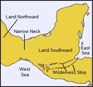
The best summary of the overall description of Book of Mormon geography is given by Mormon himself in preparation for describing some detailed wars (Alma 22:27-34). One very distinctive feature he mentions is that there was a Land Northward and a Land Southward separated by a narrow neck of land. Thus, we are looking for two lands separated by an isthmus. There are many such places in the western hemisphere, so we need to look for more clues.1.3 Nearly Surrounded by Water
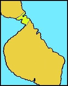
Another huge clue provided by Mormon is that the Land Southward was "nearly surrounded by water" (Alma 22:32). It had seas to the east, south, west and north (Helaman 3:8). No doubt it was for that reason that some of the first who arrived with Lehi's group believed that they were on an island (2 Nephi 10:20). Now this added information really limits possibilities, even without archaeological finds. Figure 1 shows a map drawn by J. N. Washburn in 1968 showing these two key features, without attempting to refer to any specific known location.[2]
 |
1.4 Two Advanced Cultures
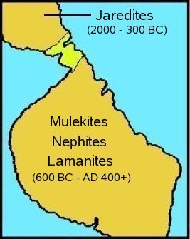
The Book of Mormon describes two main groups who migrated from the Eastern Hemisphere to the Western at very different times to different places. The first group, called Jaredites, left from the Tower of Babel (about 2000 BC), migrated north, crossed an inland sea (most likely Caspian Sea), continued on (most likely to China), and then crossed the great waters (Pacific) to come inhabit the Land Northward of the Narrow Neck. The other group (consisting of both Lehi's and Mulek's separate migrations) came from Jerusalem about 600 BC. We are only told that Lehi's route was basically to cross Arabia and then the Pacific to land in the Land Southward. During most of the period described in the book of Mormon, both Lehi's descendants (the Nephites and Lamanites) and also the Mulekites lived in the Land Southward. For the period of about 400-200 BC they were in three distinct areas of that land, with the Mulekites northernmost, the Nephites in the middle, and the Lamanites in the southern part, where Lehi first landed. Around 300-200 BC the Jaredites had a huge internal civil war in which that civilization was largely destroyed. Around AD 400 the Lamanites destroyed the Mulekites and Nephites who had stayed in that area. Figure 2 shows the approximate arrangement on Washburn's map.
 |
 |
1.5 Narrow Wilderness Strip
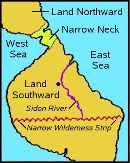
Now we begin to look at important features about which there is more disagreement among Book of Mormon scholars. The most important is probably the location of a strip of wilderness which ran all the way from the East Sea to the West Sea (Alma 22:27), that is, from the Atlantic to the Pacific Ocean. At about 100 BC, this strip separated the Nephites and Mulekites on the north from the Lamanites on the south. It was important strategically for the Nephites to close off their south border to keep the Lamanites from overrunning their land. Captain Moroni had seven cities fortified along this strip for that purpose.It is fortunate for us that the strip had strategic military importance to the Nephites because that likely caused this important clue to be included in the record. What was the nature of the "wilderness"? Does that only refer to uninhabited jungle areas? One clue is that Moroni only had to fortify cities at certain locations on the strip in order to secure it, so it must have been difficult to cross at other places. Before looking for it, let us look at one more clue.
 |
1.6 River Sidon
The only river described in the Book of Mormon is the River Sidon. It was a large enough river to throw thousands of corpses in after a battle and have them easily wash out to the sea. It is important in the history because the great city of Zarahemla, the capital of the Nephite/Mulekite civilization after they merged, was just west of the Sidon. An important geographical clue is that the head waters of the Sidon were located at the Wilderness Strip (Alma 22:29). That tells us two things. First, that area of the Wilderness Strip is mountainous, because mountains are where rivers begin. Secondly, because the strip is east-west, then at least part of the Sidon flows north, away from the mountains. Figure 5 shows Washburn's placement of the river, along with my addition of the wilderness strip and the city of Zarahemla.
 |
 |
1.7 Names of Large Lands
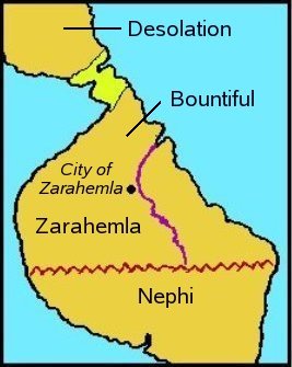
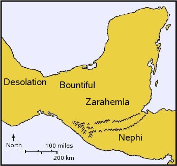
In Mormon's description of the area, he provides the names of the large areas on the map. The part of the Land Northward near the Narrow Neck was called Desolation and Bountiful was found just southward of it (Alma 22:30-31). South of that was the land of Zarahemla, which was separated from the Land of Nephi in the far south by the wilderness strip (Alma 22:34). These areas are indicated on both maps in Figures 7 and 8. Now let us turn to the puzzle.
 |
2. Limhi's Expedition
Before looking for the River Sidon, the next important landmark to identify, let us turn to one "puzzle" which the Norman map and explanatory booklet appears to solve. There are actually many puzzling aspects of Book of Mormon geography, but there is one which has been a "litmus test" for me in deciding whether or not a proposed map has a chance of being correct. Allow me to state it as a formal logic puzzle, which you may now try to solve yourself before reading Norman's solution.The puzzle is to draw the River Sidon, as well as the location of the city of Zarahemla, on a Book of Mormon internal map (such as in Figure 7, or your own), in a way to explain the following weird result of the "Limhi expedition" (Mosiah 8:7-11, 21:25-26). To me this account is difficult to explain on any map at all, so finding a solution on a real map would be compelling evidence both for the Book of Mormon being a true record, as well as the river and city being correct. This is to be done strictly as a puzzle; of course any real solution would need to correlate with archaeological finds and all the other internal details from the Book of Mormon account. Now consider the details of the puzzle that you need explain.
2.1 The Puzzle
There was a king named Limhi who lived in the southern part of the Land Southward, called the Land of Nephi. His city was in bondage to the enemy Lamanites, so he sent an expedition to get help from the great city of Zarahemla from which his grandfather had come. It was known to be just west of the River Sidon, and that river was known to have its headwaters not far north of them in the Wilderness Strip. Even though this new generation might never have been there, it hopefully wouldn't be too difficult to find given that information, and the approximate length of time needed. But what happened seems mysterious indeed.The expedition got lost (not too hard in a jungle region), found a land of many waters, and a city that they thought was indeed Zarahemla (Mosiah 21:26). But alas, the city had been destroyed long enough ago that they found only dry bones and rusted swords and armor. They were so strongly convinced that they had found Zarahemla, that they returned to King Limhi with the bad news. Nothing is mentioned about getting lost on the way home, so apparently that was not a problem.
Now for the puzzling part. The destroyed city they found was in, or beyond, the narrow neck of land, in the part of the Land Northward later called Desolation, which was separated from Bountiful in the Land Southward by the Narrow Neck (Alma 22:30-32), as shown in Figure 7. The puzzle is to draw their route and explain just how these trained scouts could have mistaken the destroyed city for Zarahemla. A solution must include 1) what they probably knew about what they were looking for, 2) what their plan had been to find it, 3) where the land of many waters was and why it was included, 4) how the destroyed Jaredite city would have met their criteria, 5) why at no point did they know that it was not Zarahemla, and 6) what their return route was. Just a note here from puzzle theory: there are several logic puzzles whose solution is based on the clue that an intelligent person was baffled by something.[5] In this case we must explain how the search party had no clue that it was not Zarahemla and enough reason to think that it was to return and report.
Okay, time to stop reading this article and go do the puzzle yourself. Simply draw any map with all of the required elements (something like Figure 7) and draw in your proposed solution of just where the expedition might have gone.
Well, how did you do? Most probably you had a difficult time. The reason the question was posed here as a formal puzzle is that it is nearly impossible to come up with any good solution using the map of Figure 7. No matter how one draws a false route from Nephi to Desolation in the Land Northward, it could easily have been known that it was not Zarahemla because it was near the ocean and way too far from the land of Nephi. It was only when I saw Garth Norman's solution that the answer became clear. To me that in itself is a witness for the Book of Mormon. That is, when allowed the latitude of drawing any map at all, one would expect the imaginary map to succeed when the real map fails. But it is the other way around.
 |
2.2 The Proposed Solution
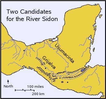
The first part of the proposed solution is to note that in the ancient world, or even today in any primitive area, the first rule of traveling without a road is to follow a stream or river if possible. The fact that we are told that the Sidon had its headwaters near the Wilderness Strip is tantamount to saying that their instructions were something like, "Find a headwater tributary of the Sidon and simply follow it for about x (some number given) days until you come to a huge city on its west side. You can't miss it." If that were the case then about the only explanation of their confusion is that they followed the wrong river, which also had headwaters in that same area, unknown to the grandfathers giving instructions, who had come the other way. There are more details to the solution, but first let's look at a real map.
 |
If there had only been one candidate for the River Sidon, Book of Mormon archaeology would probably have progressed much further by now. Because there are supporters for each of these rivers, the efforts have been divided, and hence we are unsure of just where Zarahemla was located. With all our modern technology, we have been almost as confused as Limhi's expedition. M. Wells Jakeman favored the Usumacinta River, whereas John L. Sorenson, head of the BYU Dept. of Anthropology from 1978-1986, favored the Grijalva because the archaeology is better there. He has proposed that the ruins at Santa Rosa were Zarahemla. Most researchers have followed his lead. Garth Norman, however, has maintained all along that the Usumacinta is indeed the correct solution.
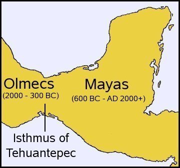
The one thing on which most researchers agree, however, is the location of the Land of Desolation, and the area of several destroyed Olmec cities which might have been confused with Zarahemla. The principal candidates seem to be La Venta, San Lorenzo, and Tres Zapotes.
Now let us return to the puzzle, and compare each of these two proposed solutions.
 |
2.3 The Grijalva as Sidon
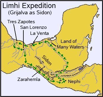
If Zarahemla is located at Santa Rosa on the Grijalva, then the search party would have been expecting a journey of about a week or two. They took some tributary of the Usumacinta by mistake and ended up in the lowland "land of many waters" near its outlet to the sea, after some 3-4 weeks. Then, after encountering the sea and no Zarahemla, they went westward for a week until encountering the Jaredite ruins. On the way home, the could not have come along the Grijalva, or they would have found the real Zarahemla, so perhaps they came south across the isthmus and followed the coastline back to where they could recognize the rest of the way home. Or they could have retraced their path all the way back. Figure 11 illustrates this scenario, with the path of the Limhi Expedition shown starting at Nephi, going along the Usumacinta to a land of many waters, discovering the ruined Jaredite cities, and then returning home by the coastal option.Many researchers have accepted this scenario, but to me it has serious problems for the scouts not to have known that the city was not Zarahemla. First, the trip home, even if they had gone directly with no wandering would have been more than twice as far as they would have expected. Second, if Zarahemla was near Santa Rosa, why would they have thought that a city near the ocean could have been Zarahemla? That whole lowland area by the sea is a "land of many waters" from the mouths of the Usumacinta all the way over past Tres Zapotes. Third, if Zarahemla were so close to Nephi, it is hard to believe that it was there for at least two centuries without being discovered by the Nephites and Lamanites.
2.4 The Usumacinta as Sidon
Now consider the other possibility, that the Sidon was the Usumacinta, and that the city of Zarahemla was in the lowlands, in a the land of many waters. That is Norman's proposal, but he only has the general area of Zarahemla predicted, roughly as shown by the large fuzzy spot in Figure 12 (it actually should be even larger, but that was the biggest my computer could draw). The archaeology remains to be done in that area to discover the exact location, but this is science at its best, when it predicts where something will be found.
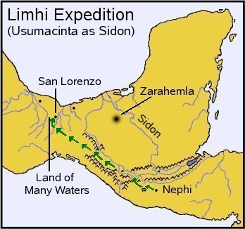 |
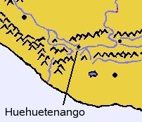
"They started at the highland valley of Huehuetenango (Cumeni, 34) where the headwaters of the Usumacinta/Sidon and the Grijalva meet. They took the wrong river, traveled north down the Grijalva instead of east on the Usumacinta tributary. When they reached the impassable Sumidaro gorge (later David crossing, 35), they continued northwest thru the Chiapas depression, dropped into the lowlands of Tabasco/Bountiful to get back on the Grijalva, but ended up on the Rio Coatzacoalcos which they mistook for the Sidon. There they found the Olmec/Jaredite ruins westward from San Lorenzo thru the southern Veracruz/Cumorah zone that appeared to them to be Zarahemla. The coastal tropical lowlands in Veracruz matches the coastal lowlands of Zarahemla in the Usumacinta Palenque district. There could not have been a better set of circumstances to make the fatal mistake, and there could hardly be a stronger geographic historic witness for the authenticity of Mormon's record in Mesoamerica."[6]
To me, Norman's argument is compelling, pending the actual discovery of the ruins of Zarahemla. My personal expertise is not in archaeology, but rather in puzzle-solving in general, so to me this is the most likely correct answer to the puzzle. Their original instructions to find Zarahemla would have been something like, "Find a tributary of the Sidon near Cumeni and follow it downstream for about 15-20 days until you come to a large city on the west side of the river in a lowland area of many waters." It explains how the trip was about the same distance to San Lorenzo as they had expected to Zarahemla, it was found west of a large river in a similar lowland setting as Zarahemla, and it also explains why the detail that they had found a land of many waters was included. They could have returned by retracing their journey, so there would have been no trouble returning home. This appears to be an excellent solution to the puzzle, but it is only one aspect of Norman's research. Let us turn briefly to his section on linguistics.
3. Linguistic Clues
In addition to the archaeological and geographical evidence, Garth Norman has included in his work some twenty locations where the modern names have roots which can be traced to either Hebrew or Nahuatl words of the same meaning as his proposed Book of Mormon locations.His list includes examples like "Sidon" being very similar to the Hebrew word for fishery (Tsidon), and that Usumacinta has been deciphered from a Maya glyph to mean "fish river." He notes that in the area where King Lamoni might have settled in Jershon, there is an ancient Maya city in Belize called "Lamani."
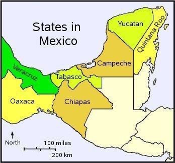 |
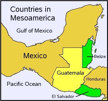
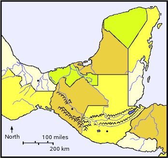
Nahuatl is beyond my ken, but I have Strong's concordance of the Hebrew Old Testament, and can easily check on his Hebrew claim. The English word "bountiful" appears twice in the Old Testament. In Proverbs 22:9, it is translated from the Hebrew word "towb," and in Isaiah 32:5 it is translated from "showa."[8] Norman suggests that the name Tabasco might be a combination of both words. To me he has won the point just with the first word. "Tob" is close enough to Tabasco to merit further research. His linguistic finds alone could prove to be very important in determining Book of Mormon geography. For reference, Figure 14 shows the geographical and political features together on one map.
 |
4. Conclusion
When one tries to fit the history given in the Book of Mormon to a map of the western hemisphere, one finds an excellent match geographically, archaeologically, culturally, and linguistically to the area of southern Mexico and Guatemala as being the setting for most of the record. Most modern scholars have agreed on the general area, with the main difference of opinion being the choice of which river best matches the description of the River Sidon. The current favorite tends to be the Grijalva River, but Garth Norman has made a strong logical argument in favor of the Usumacinta. It best explains how the Limhi expedition could mistake a destroyed Jaredite city for Zarahemla. But the final verdict must await archaeological evidence before one can be certain. In any case, Norman appears to have created the best map to date pinpointing where many events might well have occurred. Moreover, he has added linguistic evidence and detailed references. In the opinion of this reviewer, none of the other attempts at such a map have done so well. Having a map to follow the action can really help bring the story to life and to remember the events by visualizing just where they probably occurred.Notes
- Norman, V. Garth, Book of Mormon - Mesoamerican Historic Geography (American Fork, Utah: Ancient America Foundation, 2006), being the Study Text for the Mesoamerica & Book of Mormon Lands Map available at www.ancientamerica.org/library/media/HTML/7hvlmli5/book%20of%20mormon%20map.htm
- Washburn, J.N., Book of Mormon Guidebook (1968), p. 135.
- See Allen, Joseph L., Exploring the Lands of the Book of Mormon (Orem, Utah: S.A. Publishers, 1989) for the best summary of this entire subject. It is thorough, covers many aspects of the field, and is probably the most objective work at its time.
- Norman selects the southern mountain range as the wilderness strip, which is very important to his placing of Helam, the town that Alma founded for his believers.
- See puzzles number 8 and 9 on my webpage entitled "My Favorite Logic Puzzles" at www.johnpratt.com/items/puzzles/logic_puzzles.html.
- Norman, Mesoamerican Historic Geography , p.7.
- Norman, V. Garth, "A Mesoamerican Place Name for Bountiful?" Meridian Magazine (18 July 2006, republished 20 Sep 2010).
- Strong, James, The Exhaustive Concordance to the Bible (McLean, Virginia: MacDonald Pub.), p. 139, referencing his Hebrew words 2896 and 7771.